Screenshots

Overview
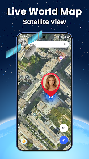
Live World Map: Satellite View Real-Time 3D Earth Navigation & GPS Location Tracker Explore the world with live satellite map, earth view, and real-time GPS navigation. With Live World Map: Satellite View, you can discover cities, countries, landmarks, and terrain using street view, satellite camera, and live location tracking - all in one powerful app. Realistic Terrain & City Maps View the Earth with realistic cityscapes and terrain.
Rotate, zoom, and navigate across interactive maps to explore mountains, rivers, buildings, and streets. Ideal for users who want to visualize places before traveling, conduct virtual tours, or explore new areas using advanced earth simulation. Live Satellite Map with Real-Time Imagery Access high-resolution satellite view of any place on Earth. The app fetches updated imagery from global GPS satellite sources to give you the most accurate picture possible.
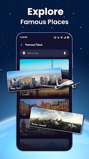
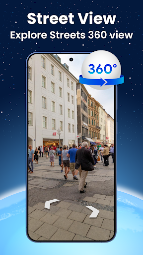
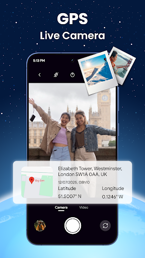
Perfect for monitoring remote locations, viewing real-world conditions, or exploring natural environments without leaving home. Street View with 360° Panorama Camera Walk through real streets using the live street view map. Move through any neighborhood, tourist spot, or urban area with full 360-degree camera control. Brings immersive virtual travel experiences to your phone, helping you prepare for trips or revisit places from anywhere. GPS Navigation & Route Finder Use the built-in GPS locator and map navigation tools to track your current position and get turn-by-turn directions to your destination. Avoid wrong turns and delays - this real-time navigation app ensures smooth routing and precise movement tracking. Smart Search for Places & Landmarks Find anything quickly - from restaurants, airports, hotels, and ATMs, to famous tourist attractions and hidden spots. Save time while traveling with one-touch.
Features
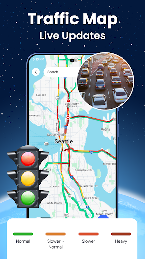
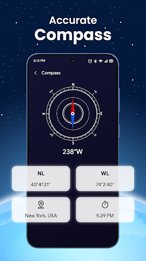
Access to nearby places through the smart location finder. Clean, Fast, and Intuitive Interface The app's modern design ensures quick access to all tools like live earth view, compass direction, satellite camera, and map overlays. No clutter, just a seamless experience for navigation, exploration, and daily use. Bonus Tools:? GPS Earth View & World Map Explorer?️ Live Earth Cam & Satellite Tracking? Compass, Speedometer, and Altitude Display?️ GPS Route Planner & Traffic View? The interface is organized for quick access to the most frequently used functions, reducing the time needed to complete common tasks. Advanced options are available for users who want to customize their experience and optimize the application for their workflow.
Data sync and backup features help users keep their information safe and accessible across multiple devices when needed. The application supports a wide range of file formats and integrates with popular services to extend its usefulness. Performance optimization ensures smooth operation even on older hardware, making it accessible to a broad user base. Comprehensive documentation and in-app guidance help new users get started quickly while power users can explore advanced capabilities. Users can organize content, apply filters, and access key functions through an intuitive layout that minimizes learning curve. Cross-platform support and cloud integration extend the application's reach across different devices and ecosystems.
Built-in tutorials and contextual help ensure that users can discover and master features at their own pace. Data sync and backup features help users keep their information safe and accessible across multiple devices when needed. The interface is organized for quick access to the most frequently used functions, reducing the time needed to complete common tasks. Advanced options are available for users who want to customize their experience and optimize the application for their workflow. Data sync and backup features help users keep their information safe and accessible across multiple devices when needed.
Pros
- User-friendly interface for smooth experience
- Comprehensive feature set for various needs
- Regular updates and maintenance
- Widely used and well-reviewed
- Good value for the functionality offered
Cons
- May have a learning curve for new users
- Some features may require subscription
- Performance may vary by device
- Interface design could be improved
- Support availability may be limited
Top Apps

Alien Food Invasion Premium
Enjoy the alien invasion without ads and without any pay-to-win purchases! br br Improve ...

Big Boss Idle Business Tycoon
BUILD, AUTOMATE, PROFIT - THE ULTIMATE IDLE BUSINESS TYCOON GAME br br Grow from $100 to ...

Christmas Magic
? Christmas Magic Watch Face for Wear OS ? br br Unwrap the joy of the season with our Ch...

Christmas Snow On/Off Watch
Collection https://play.google.com/store/apps/dev?id=5351976448109391253 br Pretty and cut...

Christmas Village
font color="#28c0fa" Perfect watch face for this Christmas season! /font br br b Teleg...

Code Blue CPR Timer
Code Blue CPR Timer was developed and extensively tested to provide crucial information in...

Coexisting Diseases & Surgery
A comprehensive medical disease app that contains the following: br br 1) Gives the descr...
Currency Converter Pro
No Ads. br br Currency Converter providing real time exchange rates for over 180+ currenc...
Similar Apps

Waymo
Get there with The World’s Most Experienced Driver ™ br br Waymo is on a mission to be th...

Bolt: Request a Ride
Make getting around easier with Bolt! Whether you need a ride across town, an airport tran...

Mgrs & Utm Map Pro
Special features at pro version: br br ? More maps (Bicycle, Topographic, Neighbo...

MTA TrainTime
The TrainTime app provides a one-stop shop for Long Island Rail Road and Metro-North Railr...

The Parking Spot
The Parking Spot app makes it easier than ever for anyone parking and flying out of an air...

Trucker Path: Truck GPS & Fuel
Trucker Path is the #1 truck navigation (Truck GPS) trusted by millions of CDL truck drive...

Yango: taxi, food, delivery
b Yango is an easy-to-use app for getting around the city /b br Fill your life with move...
Avenza Maps: Offline Mapping
Avenza Maps, the best app for hiking, biking and all trails. Featuring maps from National ...