
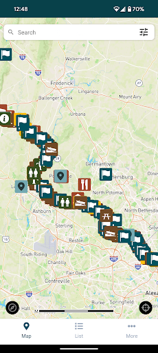
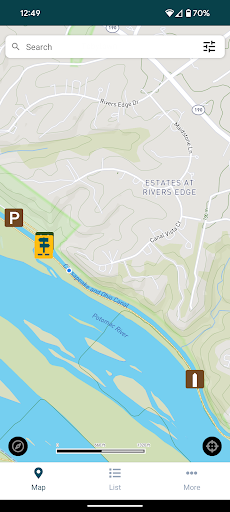
C&O Canal Explorer is a comprehensive navigation app designed to help users explore the entire 184.5 miles of the C&O Canal National Historical Park. The app serves as an essential tool for outdoor enthusiasts, providing access to over 800 meticulously mapped points of interest.
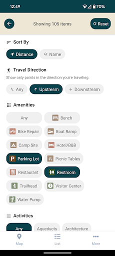
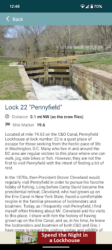
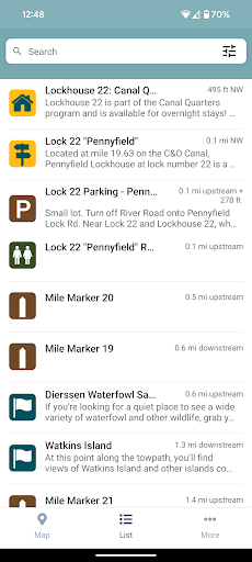
Key features include a searchable database that allows users to easily locate hiking trails, campgrounds, historical sites, trailheads, parking areas, and other important amenities. The app also incorporates a distance calculator, helping users determine how far they are from nearby points of interest and facilities.
Whether you're planning a hiking adventure or simply exploring the park's rich history, C&O Canal Explorer provides all the necessary tools to enhance your experience while encouraging you to discover new paths and hidden gems within the park.
The C&O Canal Explorer app stands out with its extensive collection of over 800 carefully curated points of interest, each accurately mapped for easy navigation. These points cover a wide range of categories including natural trails, camping spots, historical landmarks, and essential facilities.
A standout feature is the app's built-in distance calculator, which dynamically computes the distance between the user's current location and nearby amenities. This functionality ensures that visitors can efficiently plan their routes and make the most of their park exploration.
Additionally, the app's intuitive search function and well-organized interface make it easy for users to filter and find exactly what they need. Whether you're looking for a specific trailhead or want to discover new historical sites, the app's powerful search capabilities have got you covered.
User-friendly interface
Comprehensive mapping
Accurate distance calculator
Rich historical content
Offline functionality
Limited to specific park
Occasional GPS inaccuracies
No live updates
Basic visual design
Few customization options

The fastest and most convenient way to pay for parking on our lots.
 4.40
4.40
This app is military GPS coordinate systems helper. (MGRS, UTM & DMS Maps)
4.80
GPX Viewer PRO shows tracks, routes and waypoints from gpx and kml files.
4.60
America’s largest public fast charging network, with over 500 charging stations.
4.50
GPS Speedometer & Odometer: Track car, bike, truck speed & distance in real-time
4.70
NJ TRANSIT information and ticketing at your fingertips
3.70
Navigate via GPS Maps of GPS Voice Navigation, driving directions to find routes
3.60
Live Satellite view app for find GPS navigation Direction and live location map
3.70
Navigate MTA, NJ Transit, MBTA, SEPTA, BART, MARTA, CTA & 900+ cities
4.60
LIRR and Metro-North tickets and trips
4.80
Explore with GPS Navigation with GPS offline, voice GPS, speed camera radar
4.60
Track friends in real-time and explore worldwide live cameras.
4.60
Route tracker, Speedometer, Odometer, Fuel, HUD mode, save route as .GPX
4.40
Use GPS maps or search by property owner, address or parcel to view parcel data
4.30
GPS navigation offers route finder, compass, translator, currency converter, etc
4.30
GPS phone tracker, family locator, secure location sharing app
4.20
Number locator, real connection map
4.10
Navigate seamlessly with Real-Time Traffic, Offline Maps, and Voice Navigation.
4.10
OpenCPN is a full featured ChartPlotter and Navigator for Android.
3.60


User Reveiws