

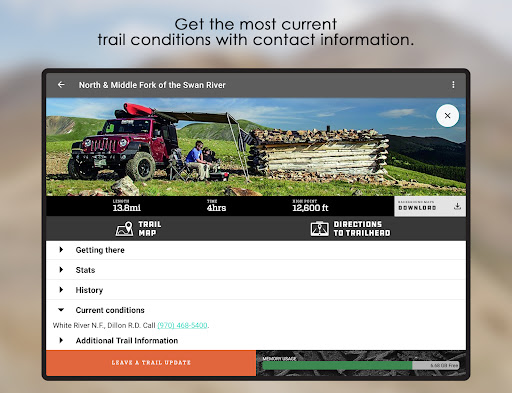
FunTreks 4x4 Offroad Trails is a comprehensive GPS companion app designed for off-road enthusiasts exploring trails in Colorado, California, Arizona, and Moab, Utah. The app provides detailed trail information including descriptions, difficulty ratings, driving directions, and estimated times, ensuring users have reliable data for their adventures.
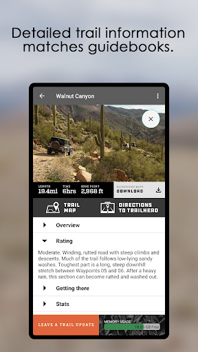
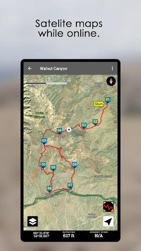
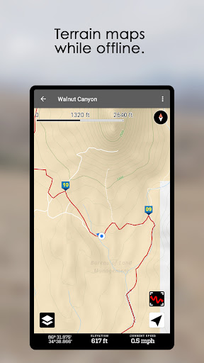
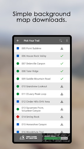
With over 600 popular off-road trails, FunTreks offers essential details such as trail length, highest elevation points, best visiting seasons, and contact information for current conditions. Additionally, the app includes GPS track logs with waypoints that align perfectly with the FunTreks 4x4 guidebooks, enhancing navigation accuracy.
This app is particularly useful for adventurers who own the FunTreks 4x4 guidebooks, as it complements the books by providing real-time GPS data and additional resources like custom-drawn maps and photos, making every off-road journey safer and more enjoyable.
FunTreks 4x4 Offroad Trails stands out with its meticulously documented trail information gathered by experienced scouts. Each trail comes with comprehensive details such as difficulty ratings, precise driving directions, and estimated driving times, allowing users to plan their trips effectively.
The inclusion of GPS track logs with waypoints ensures accurate navigation, matching the trails described in the FunTreks 4x4 guidebooks. This feature is invaluable for users who require exact positioning and tracking during their off-road expeditions, offering peace of mind and enhancing safety.
Moreover, the app provides up-to-date contact information for trail conditions, ensuring users are well-prepared for any challenges they might face. By integrating seamlessly with the guidebooks, FunTreks 4x4 Offroad Trails delivers an enriched experience through additional visual aids like custom-drawn maps and trail photos.
Accurate GPS data
Comprehensive trail info
Real-time updates
User-friendly interface
Integration with guidebooks
Requires guidebooks
Limited regional coverage
No offline maps
Subscription needed
Occasional bugs

Start your next adventure confidently using our Accurate Compass App
 3.70
3.70
OpenCPN is a full featured ChartPlotter and Navigator for Android.
3.60
Number locator, real connection map
4.10
Track accurate speed & distance with GPS Speedometer. Check speed limit & time.
4.50
Navigate confidently with our precise Digital Compass app & Direction Compass!
4.70
Parcel map, property lines, owner, acres, land use, zoning and more from Regrid.
4.60
ParkWhiz, an Arrive Mobility brand, part of the Arrive Network
4.30
MapQuest is your go-to app for maps, GPS, voice navigation & live traffic.
3.80
Get real-time bus and train schedules for easy, hassle-free city transportation.
3.90
Find shortest way and save energy . Distance and area calculator.
4.70
Find EV & Tesla charging stations with PlugShare
4.70
Find radar maps, GPS coordinates, altitude, offline maps, location, travel route
4.40
Use GPS maps or search by property owner, address or parcel to view parcel data
4.30
Maps, Driving Directions & GPS navigation using directions app & GPS App
4.30
GPS navigation offers route finder, compass, translator, currency converter, etc
4.30
Find routes fast with GPS Maps, GPS Navigation & driving directions.
4.10
Navigation, weather, offline maps & tools for smarter, safer travel planning.
4.00
Discover over 800 points of interest along the canal.
3.70
Your real-time window to the world. Explore anywhere, anytime.
3.30


User Reveiws