
Transit Tracker+ - NYC is a comprehensive navigation app designed for public transit users in New York City. This ad-free version offers advanced features beyond the basic Transit Tracker, including real-time vehicle tracking and route schedules. The app leverages MTA's Bus Time API to provide accurate data on bus and train movements, ensuring that commuters can plan their journeys effectively.
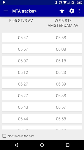
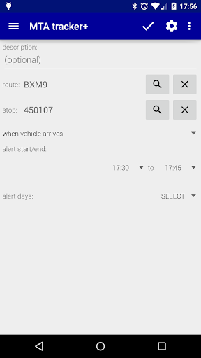
One of the standout features of Transit Tracker+ is its alert system. Users can set notifications for when a vehicle on a specific route is approaching or arriving at a particular stop. This functionality is particularly useful for those who need to time their departure from home or office precisely. Additionally, the app provides detailed route schedules that can be viewed as origin/destination tables or on an interactive map, enhancing the user's ability to navigate the city efficiently.
The app also includes a 'Close Stops' feature, allowing users to find nearby transit stops based on their current location or a selected address. With options to filter results by route and specify the maximum number of stops to display, this tool ensures that users can quickly identify the nearest transit points. Overall, Transit Tracker+ - NYC serves as an essential companion for navigating the complexities of New York's public transportation network.
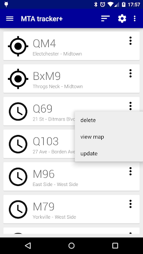
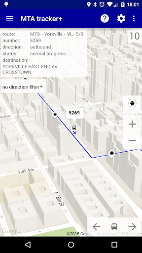
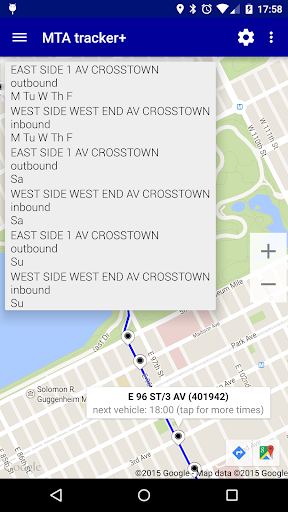
Transit Tracker+ - NYC boasts a variety of features that cater to the needs of frequent public transit users. At its core, the app provides real-time tracking of MTA vehicles, enabling users to see the exact location of buses and trains on selected routes. By entering a route number, stop number, or vehicle number, users can access detailed information about upcoming arrivals and departures, helping them make informed decisions about their travel plans.
In addition to real-time tracking, the app offers robust route schedule functionality. Users can request schedules for any MTA route and view them either as origin/destination tables or on a map interface. This dual presentation allows for greater flexibility in how users digest information, whether they prefer a traditional timetable format or a more visual representation. The map feature also integrates satellite imagery and color-coded traffic data, providing context about current road conditions.
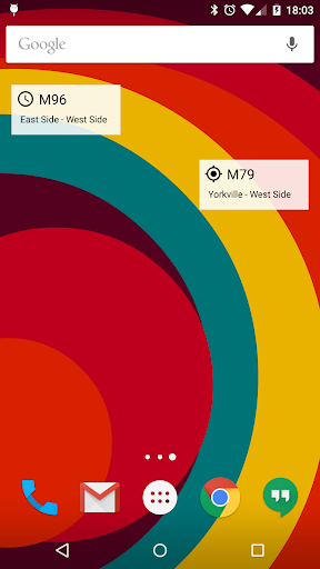
Another notable aspect of Transit Tracker+ is its customization options. Users can personalize their experience by choosing between light and dark themes, adjusting update intervals for vehicle locations, and selecting custom ringtones for alerts. These settings ensure that the app adapts to individual preferences and usage patterns, enhancing overall satisfaction and usability. Furthermore, the inclusion of widgets and shortcuts on the home screen streamlines access to frequently used features, making daily commutes smoother and more predictable.
User-friendly interface
Real-time tracking
Customizable alerts
Comprehensive route info
Ad-free experience
Limited route support
No official MTA app
Potential detours
Dependent on MTA data
Location accuracy

Offline maps for phone and smart watch: topographic maps, satellite images...
 3.30
3.30
Easy, Moderate and difficult offroad adventures.
4.00
Discover over 800 points of interest along the canal.
3.70
Find 93 Octane Gas: Locate Gasoline Stations Selling Premium 93 Octane or Higher
4.4
Turn your tablet or Android powered unit into a full blow Android Auto headunit.
2.30
Voice GPS with driving directions, offline maps navigation GPS for safe travel
4.50
Navigate via GPS Maps of GPS Voice Navigation, driving directions to find routes
3.60
Find routes fast with GPS Maps, GPS Navigation & driving directions.
4.10
Neshan: map & navigation app with 20M+ monthly active users
4.50
LIRR and Metro-North tickets and trips
4.80
Order a cab online. An affordable taxi ride and driver in no time. What a bolt!
4.80
Find AI powered cameras, ALPRs, and other surveillance infrastructure near you
4.70
Find shortest way and save energy . Distance and area calculator.
4.70
Park in Chicago, NYC, Boston, SF, Houston & more!
4.70
GPX Viewer PRO shows tracks, routes and waypoints from gpx and kml files.
4.60
Find trails, organize your locations and navigate with offline maps.
4.60
Navigate MTA, NJ Transit, MBTA, SEPTA, BART, MARTA, CTA & 900+ cities
4.60
Use GPS Maps and GPS Voice Navigation to find your way and get directions
4.10
Your real-time window to the world. Explore anywhere, anytime.
3.30

User Reveiws